PROGRAMME 2021-2027
Priority 2 Water-smart societies
Objective 2.2 Blue economy
Wrap-up of project achievements
In the southeastern Baltic Sea, missing gravity data made navigation and offshore planning less reliable. The BalMarGrav project brought together national sectoral agencies, scientists, and industry to harmonise this crucial information—building a shared foundation for safer navigation, resilient offshore infrastructure, and smoother sea traffic management.
Project achievements
The project BalMarGrav has successfully addressed the challenge of insufficient marine gravity data by building up a transnational network of the relevant experts in the region, saving and reprocessing the fragmented historical data and providing harmonised and validated open data products.
In a nutshell, the project created a harmonized set of modern and historical marine gravity data for the southern and eastern Baltic Sea, re-processed into a consistent format. It also produced detailed gravity anomaly maps, giving navigation, offshore planning, and sea traffic management a reliable shared data foundation.
Access the reports
Project Statistics
Project
Details
Project type
Small project
Project duration
August 2021 – November 2027
Contribution to the EUSBSR
PA Spatial Planning
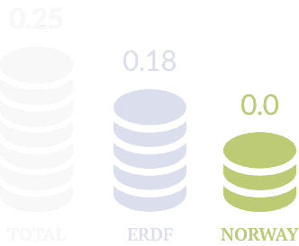
Budget in million
EURO

Involved
Countries
Lead partner
Project partners

Highlights
BalMarGrav
The BalMarGrav project set out with a clear ambition: to bring decades of scattered marine gravity data together into a single, reliable source for the Baltic Sea. What once existed as fragmented records in archives has now been transformed into a unified dataset that is ready to serve the needs of sectoral agencies, national authorities, and scientific institutions working with geodetic reference systems, gravity databases, and geoid models.
At the heart of this effort was the recovery of 15 historical marine gravity datasets, secured from various archives. These were carefully reprocessed and validated against 16 modern datasets, ensuring accuracy and consistency. The result is a homogenised historical dataset that revives valuable legacy measurements and aligns them with today’s scientific standards. Remarkably, the revitalised data proved to be of a quality comparable to modern observations, as confirmed by comparisons with regional and global gravity models.
The project’s success was not achieved in isolation. National agencies and research institutes in Germany, Lithuania, and Poland played an active role, testing and integrating the new dataset into their own databases. This collaboration ensured that the benefits extended across borders and into key international repositories, such as the Nordic Geodetic Commission gravity database and the International Gravimetric Bureau.
Thanks to this achievement, BalMarGrav rectified a long-standing gap in the south-eastern Baltic Sea, strengthening the accuracy of the updated Baltic Sea Chart Datum 2000 (BSCD2000) and directly supporting safer navigation.
Interreg pays off
Spin offs
One of the most excitingoutcomes was the creation of a high-quality dataset covering almost the entire southern and eastern Baltic Sea—a scope far beyond initial expectations. This was made possible by the extraordinary commitment of the project partners and the surprisingly good quality of much of the historical material. The dataset now paves the way for future geoid model calculations, supports offshore engineering and renewable energy projects, enriches geoscientific research, and provides a blueprint for revitalising historical gravity data elsewhere.

Project Wrap-Up
Thanks to Interreg funding and transnational cooperation, the BalMarGrav project substantially advanced knowledge of the Baltic Sea by closing long-standing gaps in marine gravity data. Today, sectoral agencies, international maritime and hydrographic organisations, and researchers across the region can rely on a unified dataset that enhances safe ship navigation, supports offshore wind energy, and fuels new scientific and innovative insights.


