

The EcoSensitivity tool offers Baltic Sea responders an advantage in fighting oil spills
26 May 2025
As one of the world’s most trafficked and environmentally sensitive marine regions, the Baltic Sea faces the continuous threat of oil spills — disasters that can undo years of restoration work in a single day. Responding fast and smart is essential to minimize the impacts on nature. To tackle this challenge, the OpenRisk II team has created EcoSensitivity, a web-based tool that helps responders go from knowing What might leak? to Where will the leaked substance go? to Which natural treasures will suffer? in just a few clicks.
“This tool didn’t appear overnight,” says Jonne Kotta, professor at the Estonian Marine Institute, University of Tartu, and one of the developers of EcoSensitivity. Long before OpenRisk II, there were three stand-alone research tools, now combined into one easy-to-use web platform. Under the umbrella of EcoSensitivity, the Accidental Damage and Spill Assessment Model (ADSAM) is used to describe the accidents, Seatrack Web for predicting the drifting of the oil and PlanWise4Blue for estimating the cumulative impacts on nature.
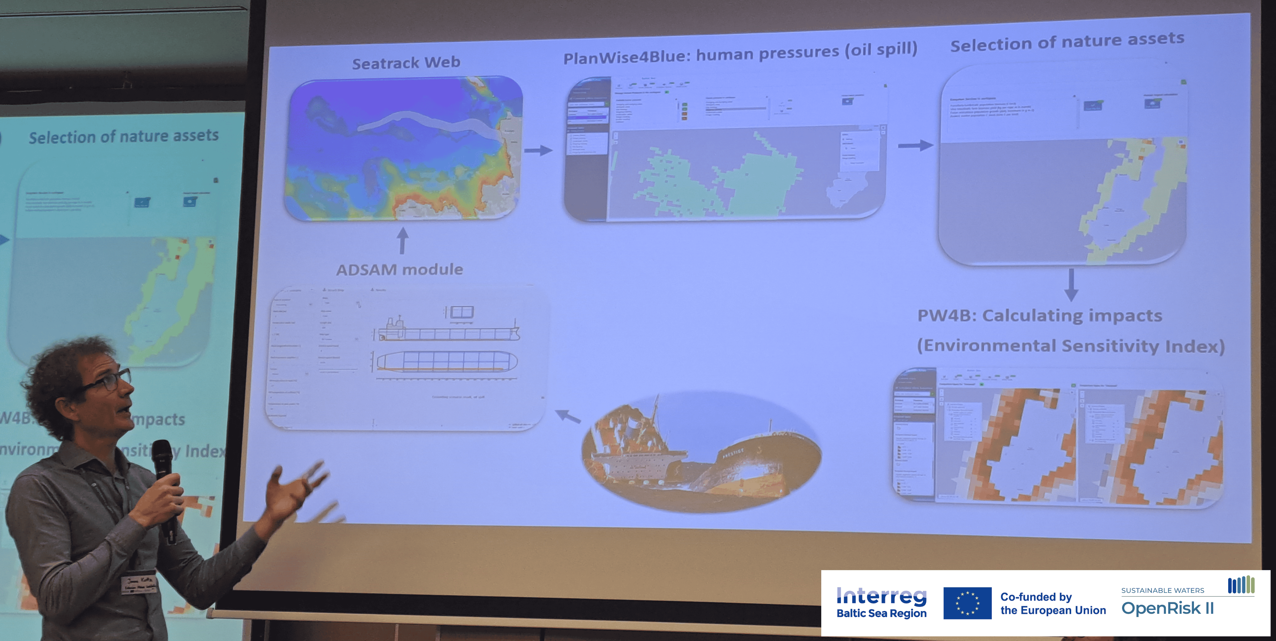
Jonne Kotta presenting the functionalities of the EcoSensitivity tool at the OpenRisk II Mid-term conference organized in Tallinn, Estonia from the 26th to 27th of March 2025.
What once demanded three experts and multiple programs now unfolds in a single browser tab. “Because the platform is cloud-based, officers in different countries can look at the same scenario, discuss their options in real time and record every step for later review. Exercises using the tool show that decisions which once required an hour can now be made in ten minutes. Less delay means smaller slicks, fewer birds oiled and lower clean-up bills,” Kotta continues.
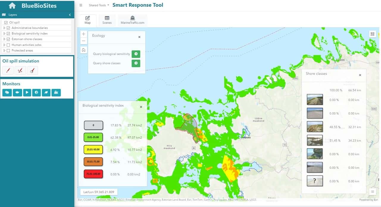
The tool can be access at gis.sea.ee/bluebiosites/
Practical impact already emerging
Though EcoSensitivity has not yet been used in a live emergency, individual modules are already proving their worth. For example, the oil‑drift component is used in navy drills, and the cumulative‑impact engine supports environmental reviews of planned offshore wind farms.
In Estonia the primary user of the tool will be the Estonian Navy, which leads on‑water oil‑spill response. “We’ve worked closely with the navy throughout development to ensure that every feature supports real-world response routines,” says Kotta. Navy officers report that the shared map broadens their tactical options and improves coordination, for example, with Finnish partners during joint cross‑border exercises in the Gulf of Finland.
EcoSensitivity combines oil drift forecasts with shoreline vulnerability data, enabling responders to prioritize protection of the most sensitive ecosystems. It even helps identify areas where oil could be diverted or more easily cleaned up. “The tool lets them forecast spill behavior, visualize the full footprint, and identify the most vulnerable coastal stretches. A sandy beach is far easier and cheaper to clean than a rocky coastline. Having that clarity ahead of time is crucial.” notes Anneliis Kõivupuu from the Estonian Marine Institute, University of Tartu, who also contributed to the tool’s development.
Anneliis Kõivupuu has had a key role in managing the OpenRisk II project activities at the Estonian Marine Institute, University of Tartu.
The platform also serves as a shared decision-making space for different authorities. The Estonian Navy and the national Transport Administration are now offered a common digital workspace, ensuring their response actions are aligned and based on the same up-to-date risk picture.
Looking to the future
As with any evolving tool, improvements to functionality and data will continue throughout the remainder of the project. “Progress really depends on what high-resolution datasets can be shared across borders. The more detailed our inputs, the more accurate our risk assessments,” says Kotta. At the Baltic Sea scale, the tool already integrates all relevant HELCOM data layers, which will be regularly updated in line with HELCOM revisions.
The EcoSensitivity tool combines three existing tools into one easy-to-use web platform.
Additional data is expected from the Horizon Europe-funded PROTECT BALTIC project, a broader and more detailed set of nature asset maps, enabling even more refined environmental risk and impact assessments. These additions will make EcoSensitivity even more effective in identifying ecological risks and targeting mitigation efforts. “The aim is to make the tool as practical and useful as possible for the end users. We will continue to collect feedback from different countries to guide further refinements,” Kõivupuu notes.
The objective is to get EcoSensitivity adopted by national Baltic Sea transport authorities responsible for monitoring maritime traffic and managing sea-based risks, alongside agencies tasked with operational oil spill response. “By providing a shared regional view of oil drift and pinpointing the most at-risk ecosystems, the tool enables faster, coordinated cross-border responses when time is critical,” Kõivupuu emphasizes. “We want EcoSensitivity to become a standard tool across the Baltic Sea region,” Kõivupuu concludes.

Additional links
details
-
Homepage
-
Project typeCore Project

-
ImplementationNovember 2023 - October 2026
-
StatusOngoing
-
Contribution to EUSBSRPolicy Area Safe, Policy Area Ship

-
Target groups
- Higher education and research institution
- International governmental organisation
- National public authority
-
Social media
-
Additional links
-
Tags