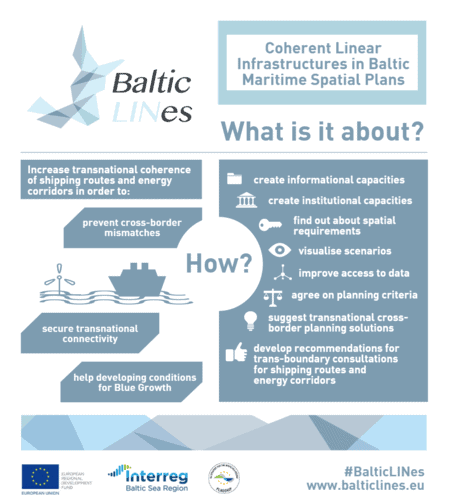
The Baltic Sea experiences an increasing demand for coherent spatial planning in order to bring shipping routes and offshore renewable energy infrastructure together. Project partners from nine countries worked across borders to tackle the challenge of scarce space available and competing economic interests of the different sectors active in and around the Baltic Sea in the Interreg project Baltic LINes.

© BalticLINes/Liene Strazdiņa
What are the challenges for Baltic LINes?
Planning the national sea area is a complex task where the different sectoral interests need to be carefully weighed against each other. For example, it requires finding balance between the economic interests of the shipping industry, the offshore energy industries and fisheries, and the space needed for environmental protection or recreational uses. Coherent planning across borders and aligning national maritime spatial plans to ensure an efficient and optimal use of the sea space was a key challenge tackled in the Interreg Baltic Sea Region project Baltic LINes. Throughout its activities, the project stressed out the importance of up-to-date transnational data; it analysed trends and developed future scenarios for shipping and energy sectors. Quite importantly, it also established criteria and tools for the stakeholder involvement.
One of key activity areas for Baltic LINes was developing solutions for coherent planning of linear infrastructure, such as cables and pipelines. The project concentrated on the identification of planning mismatches between shipping and renewable energy sectors in border areas and collected methods how these could be avoided or solved. For example, ship corridors can have different widths in one country as compared to its continuation in the next bordering country. This might result in major planning mismatches in the future.
It is all about the data
 A crucial and fundamental prerequisite for transnationally coherent planning is access to data as well as the availability of the datasets. However, maritime spatial planners lack up-to-date and relevant data from neighbouring countries. To cope with that issue, Baltic LINes developed a prototype of a web application to provide decentralised access to data and metadata stored in national Marine Spatial Data Infrastructures across the countries around the Baltic Sea.
The application’s demo BASEMAPS offers an open interactive map of the Baltic Sea region in which, for example, information on the telecommunications and data cables published by one country is readily available to its neighbours. In this way, the application can be used for harmonisation purposes. More information about the process of data collection as well as the data tool development is available here.
Key facts about the project Baltic LINes
Efficient co-existing of shipping and offshore energy in the Baltic Sea
In the course of meetings on national approaches to handling shipping and energy in maritime spatial planning (MSP), stakeholder consultations and country representative interviews, the project gathered valuable experts’ knowledge. A set of cases was identified along with proposed solutions, for example for colliding shipping corridors and planned offshore wind farm west of Sareema Island, primarily affecting Estonia, Latvia and Sweden. The project also identified the most commonly used planning criteria and described factors used by the countries around the Baltic Sea to assess, regulate and select suitable areas for offshore wind farms, cable corridors and shipping corridors. Among other things, planning offshore wind farms requires considering physical and natural conditions like water depth, wind and seabed conditions; socio-economic factors like distance to shore; as well as technical requirements like connection to the onshore grid and the relation to other sea uses and functions (i.e. protected areas, exclusion of priority areas for other sea uses). Practical guides recommend on step-wise approaches for the designation of areas for shipping and offshore energy in national MSP and aim to help planners in the MSP draft phase.
Even though the legal status of national MSPs differs and it turns out that achieving a fully synchronised planning approach is challenging, the collection of information increases common understanding and aligns methods between countries.
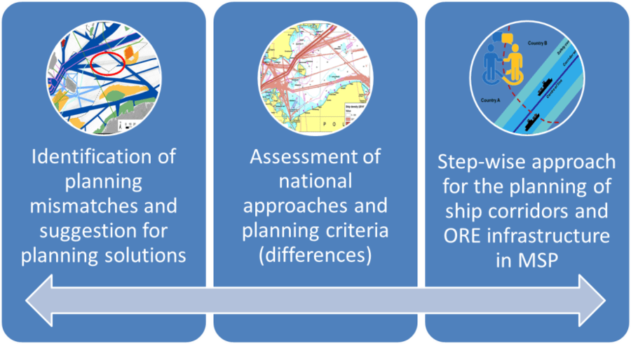
An approach towards planning issues, planning criteria and planning solutions by Baltic LINes.
Unique stakeholder involvement through the MSP Challenge Simulation Platform
Coherent spatial planning across borders requires involving national and transnational stakeholders from the energy and shipping sectors, along with their knowledge, experience, and long-term vision for the future. During interactive workshops in Riga, Latvia, and Copenhagen, Denmark, experts discussed the future scenarios of shipping and energy respectively. In a workshop in Hamburg, Germany, different experts worked together with planners to explore how to integrate the diverging interests into one scenario. All with the help of the MSP Challenge Simulation Platform – a flexible simulation & gaming platform that integrates dozens of GIS datasets from HELCOM into a dynamic and interactive map of the Baltic Sea, with shipping, energy and ecosystem simulations running in the background. The stakeholders’ views and the results from all three workshops were used to improve the future scenario building activities.
“The platform helps its users understand and try to work with the complexity of maritime spatial planning. It simulates ship traffic and energy production capacity based on existing and planned shipping routes and offshore wind farms, all enabling in-depth explorations of possible futures of shipping and energy in the Baltic Sea, while mitigating environmental impacts,” said Harald Warmelink, Breda University of Applied Sciences.
Future of shipping and offshore energy in the Baltic Sea
It is essential that the spatial plans are not only taking into account the current situation, but also looking how to include the interest of each sector in the future. For this reason, Baltic LINes went beyond only analysing the trends; it developed scenarios for shipping and energy sectors instead. The project made forecasts the development of the shipping sector by means of the scenarios building activities done under the project where the transnational cooperation has been a key factor for a successful result. The reports about the future of shipping and energy outline the changes of the global, external and internal factors. They provide recommendations for MSP authorities and stakeholders from different sectors to take into consideration for example, the autonomous shipping, growing offshore services, changes in shipping pattern.
NorthSEE and Baltic LINes connect the seas
BalticLINes and its sister project NorthSEE, co-funded by Interreg North Sea Region, held a joint MSP conference “Connecting Seas” to present the projects’ achievements in terms of coordinating maritime spatial planning, and to discuss trends and recommendations for shipping, offshore energy and environmental protection. More information about solving maritime spatial planning challenges across borders discussed at the event you will find here and in the video below.
Article written by Liene Strazdiņa, VASAB Secretariat