The BalMarGrav Story
22 November 2024
The BalMarGrav project, co-financed under the Interreg Baltic Sea Region 2021-2027 program, aimed to improve the insufficient mapping of the marine gravity field in the southern and eastern Baltic Sea region. This task is very important due to the decision of the Baltic Sea Hydrographic Commission to implement a common height reference system (Baltic Sea Chart Datum 2000) for the Baltic Sea Region which is consistent to the European height system. This means that bathymetric measurements, nautical charts etc., which are needed for safe navigation, offshore infrastructure and sea traffic management, will be based on a so-called geoid model, just determined by measurements of the acceleration due to the gravity field of the Earth.
What do we need?
Orientation in space has been a very important issue since the early days of mankind. Many techniques can be used to resolve this task. It is now common practice to use the Global Navigation Satellite Systems (GNSS), commonly called GPS after the first system of its kind. However, GPS determines the position relative to the centre of the Earth’s mass. So, there is a need to relate these measurements to the sea surface, particularly in relation to what we experience as heights in daily life. In this case, a surface called geoid can be used. Models of the geoid are computed from measurements of the acceleration due to the gravity field of the Earth. However, high-resolution terrestrial gravity measurements at sea are very expensive, mostly due to the requirement of dedicated survey vessels and ship time. It is therefore prudent to explore the possibility of reviving available historical marine gravity data and testing their potential for current needs.
How can we achieve it?
Traveling on a ship at sea or by car on land, we would like to use our navigation system regardless of our location and across national borders. This goal can only be achieved through international collaboration. The BalMarGrav project, co-financed by the European Union Interreg Baltic Sea Region 2021-2027 Programme, has built up a network of experts from 11 institutions — sectoral agencies responsible for geodetic systems, universities and research institutes, supported by 6 Associated Organizations, respectively from Denmark, Estonia, Finland, Germany, Latvia, Lithuania, Norway, Poland and Sweden — to revitalize gravimetric surveys carried out in the southern and eastern Baltic Sea between the 1950s and 1990s.
What have we done?
During the BalMarGrav project, 15 historical marine gravity datasets were secured from archives, reprocessed and validated by 16 modern marine gravity datasets. As a result, a single homogenized historical dataset for the southern and eastern Baltic Sea was developed. The good quality of the revitalized data, comparable to that of modern marine gravity measurements, was confirmed by comparisons with regional and global gravity models from different sources and techniques.
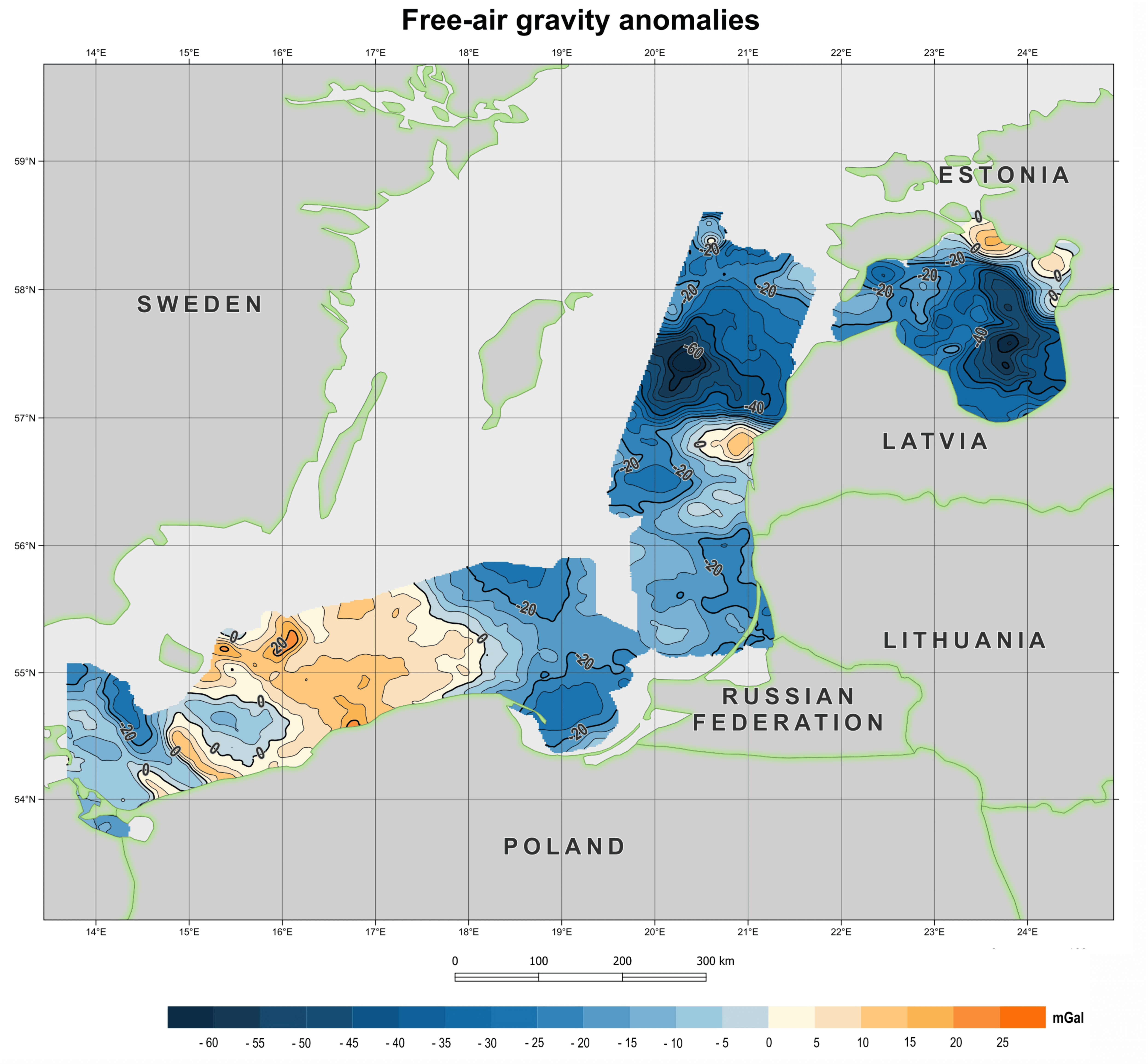
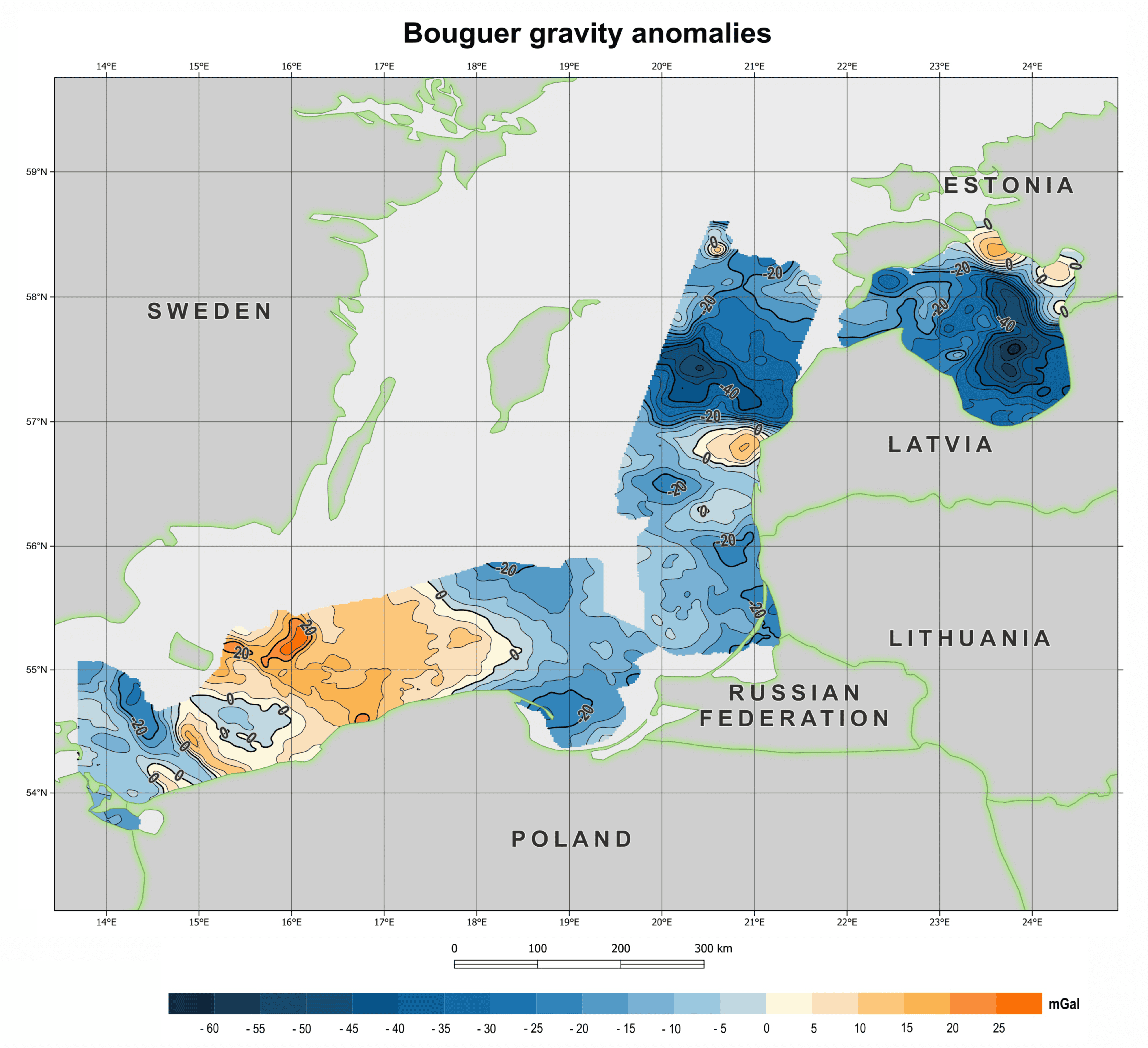
The homogenized historical marine gravity dataset has been incorporated into the national and international databases, such as German, Polish and Lithuanian national databases, the Nordic Geodetic Commission gravity database, and the International Gravimetric Bureau. The download of the developed dataset from the Nordic Geodetic Commission gravity database was tested by 11 institutions, including 7 institutions that are not Project Partners or Associated Organizations. In addition, 3 reports on historical (here), modern (here) and homogenized marine gravity datasets (here), as well as maps of the so-called free-air gravity anomaly and the Bouguer anomaly have been developed for public use and posted for free download at the project web-page (here).
What can we do next?
The data can be used, for example, for future calculation of the geoid model for the Baltic Sea in order to obtain a more accurate and reliable height reference surface for satellite-based height determination. This is important for maritime navigation, as a better estimation of the clearance under the ship helps to both optimize ship’s route and safety, for example in deciding how much cargo a ship can carry and where it can enter. Another increasingly important application is in offshore engineering, such as wind farms. The developed datasets can be also used by geologists and geophysicists as one piece of information in interpreting the internal structure of the Earth. Finally, the reprocessing and homogenization schemes developed within the project can serve as inspiration for researchers to revitalize historical gravity data.


